








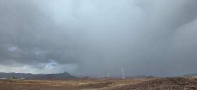

Oman rainfall brings thunderstorms and hail across Hajar Mountains
Heavy thunderstorms swept across sections of the Hajar Mountains on 19–20 August 2026, producing localized hail, strong downdraft winds and runoff in several governorates. Oman rainfall from the system was concentrated in interior and northern mountain districts and triggered the flow of multiple wadis, according to the Ministry of Agriculture, Fisheries and Water Resources.
The storms affected Al Buraimi, Al Dhahirah, Al Dakhiliyah, North Al Sharqiyah and South Al Batinah, with intense cells over parts of Al Jabal Al Akhdar and Al Hamra. Officials said the convective activity was brief but produced significant surface runoff and hail in some villages, prompting local authorities to monitor low-lying routes and wadi crossings.
Oman rainfall: recorded totals and regional hotspots
The ministry’s preliminary rainfall totals for 19–20 August show Al Hamra recorded the highest accumulation at 74 millimetres, followed by Dema Wa Ta’een with 42 mm and Al Jabal Al Akhdar with 30 mm. Other notable totals included Ibri with 24 mm, Al Mudhaibi 23 mm, and both Al Qabil and Al Rustaq registering 22 mm each, the ministry stated.
Additional readings reported by the ministry included Sohar 20 mm, Ibra 17 mm, Nakhl 16 mm, Samail 13 mm and Salalah 11 mm. Smaller amounts were recorded across several interior wilayats, such as Wadi Bani Khalid and Bidbid with 7 mm each, Al Buraimi and Bidiya at 6 mm, Nizwa 5 mm and Izki 4 mm. These figures emphasize the patchy nature of convective rainfall in mountainous terrain.
Local impacts: wadis, hail and infrastructure
Storms produced noticeable impacts in several localities as steep terrain and hardened soil facilitated rapid runoff. In Al Dhahirah’s Ibri area and its surrounding foothills, heavy showers driven by gusty winds and hail led to the temporary flow of valleys and smaller streams. Meanwhile, eastern routes through parts of Al Dakhiliyah saw runoff from tributaries of larger wadis.
In South Al Batinah, areas around Al Rustaq and Al Awabi experienced localized heavy rain and hail that prompted flows in Wadi Bani Khawf and other channels. Furthermore, authorities reported that roads that cross seasonal wadis became temporarily hazardous where water levels rose, and motorists were advised to avoid crossing moving water. Emergency services remained on alert for flooding incidents and localized property damage.
Evacuation and safety measures
Local civil defence and municipal teams issued advisories for residents in low-lying neighborhoods and near wadi beds to exercise caution. Meanwhile, road authorities temporarily closed or monitored vulnerable stretches of mountain and wadi-crossing roads until waters receded. The ministry urged communities to follow official guidance and avoid flash-flood-prone areas during and after storms.
Why these storms developed and what they mean
These convective storms intensified over the Hajar range due to daytime heating and orographic uplift as moist air rose over mountain slopes, meteorologists explained. The combination of instability, localized moisture and terrain features often yields sudden, heavy downpours and hail during the late summer months in northern and interior Oman.
Although isolated, such events can rapidly produce flash flooding in otherwise dry channels and overwhelm small drainage systems. Therefore, the observed Oman rainfall underscores the need for continued monitoring of mountain catchments and for public awareness about the risks of driving through wadi crossings after heavy rains.
Official reporting and data from the ministry
The Ministry of Agriculture, Fisheries and Water Resources compiled the rainfall data from the 19–20 August period and provided the totals to regional authorities for situational response. Officials emphasized that the numbers are preliminary and that field teams are validating station readings and assessing damage reports where flows were noted.
Authorities also pointed out that localized hail and strong downdraft winds, while short-lived, contributed to sudden accumulation in pockets that may not be fully captured by a limited network of observation stations. Therefore, residents were reminded that official totals can evolve as more observations and reports are consolidated.
Outlook and next steps
Forecasts for the coming days indicate a chance of residual convective activity in the interior highlands, though widespread systems are not expected immediately. Meteorological services will continue issuing updates and short-range warnings if new cells develop over the Hajar Mountains or coastal foothills.
For the public, the next steps are clear: monitor official weather briefings, heed civil defence advisories, and avoid crossing flooded wadis. Authorities will continue field inspections of affected routes and infrastructure and will publish consolidated rainfall and impact reports when available.
In summary, Oman rainfall on 19–20 August produced localized but significant impacts across mountain and interior districts. Residents and visitors should watch for further updates over the next 24–72 hours as officials validate measurements and assess any remaining hazards.