







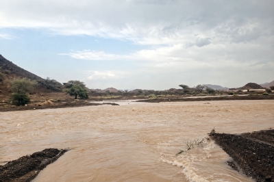

Oman thunderstorms hit multiple governorates with variable heavy rain
Oman thunderstorms struck several governorates from 22 to 24 August 2026, bringing variable heavy rain, strong winds and isolated hail. According to the Ministry of Agriculture, Fisheries and Water Resources, the most intense cell rainfall was recorded in Al Hamra, with numerous wadis and seasonal streams running in mountainous and adjacent areas.
The storms affected parts of Al Dakhiliyah, Ad Dhahirah, Al Buraimi, Al Wusta and Dhofar, with localized hail and wind gusts reported. Officials said monitors recorded up to 28 millimeters in Al Hamra and notable accumulations in Mahdah, Ibri and Nizwa during the three-day period.
Oman thunderstorms: areas affected and rainfall distribution
Rainfall was concentrated on the central mountain ranges and nearby settlements. In Al Dakhiliyah Governorate, Al Hamra and sections of Jebel Akhdar experienced thunderous downpours, while Nizwa and several surrounding villages registered lighter but steady rain. Bahla villages such as Al Fath and nearby communities also saw medium to heavy showers that drove run-off into local wadis.
In Ad Dhahirah Governorate, Ibri reported scattered thunderstorms with hail in some valleys and villages including Wadi Al-Hajr and Al-Humayniyah areas. The western parts of Yanqul received heavy rain in pockets, while Dhank saw rainfall in its northern village of Qumaira. Al Buraimi recorded varied bursts of rain across its wilayats, notably in Mahdah where storms triggered flow in small streams.
On the coast and in lowland areas, the governorate of Al Buraimi and parts of Al Wusta saw mixed intensities. Salalah in Dhofar registered rainfall during the reporting period, and the town of Taqah recorded measurable rainfall as well. Jabal Sahtan in Rustaq experienced light rain, while parts of Haima in Al Wusta reported wet conditions.
Official distribution figures published by the ministry list the highest three-day totals as 28 millimeters in Al Hamra, and 19 millimeters each in Al Buraimi, Ibri and Nizwa. Salalah recorded 14 millimeters, Taqah 9 millimeters, Haima 8 millimeters and 7 millimeters in Samail and other outlying localities. The ministry emphasized that totals varied significantly across short distances.
Infrastructure, agriculture and waterways: immediate impacts
Thunderstorms and sudden downpours produced rapid responses in the mountain drainage systems, causing several ephemeral wadis and gullies to run. Therefore, local authorities issued advisories for motorists and residents in low-lying neighborhoods to exercise caution near crossing points and temporary channels.
Farmers and pastoralists faced mixed outcomes. While the rain benefits grazing and recharge of small catchments, officials warned that hail and sudden flows can damage crops and undermine terraces in vulnerable areas. Furthermore, flash flows in steep terrain increase the risk of soil erosion and damage to rural tracks, limiting access for repair crews.
Water resource managers noted that the rainfall contributed to short-term replenishment of smaller reservoirs and surface catchments. According to the ministry, these events offer localized relief but are not equivalent to sustained seasonal recharge, so agricultural planners are watching soil moisture and downstream delivery closely.
Forecast, safety guidance and monitoring
Meteorological services continue to monitor instability over the Omani interior and coastal fringes, with the potential for isolated convective storms to recur under favorable conditions. Citizens were urged to follow official weather updates and avoid crossing flooded wadis, a leading cause of weather-related incidents in the region.
Authorities recommended simple precautions: secure loose outdoor items against gusts, keep clear of watercourses during and after heavy rain, and avoid driving through standing or flowing water. Emergency responders remain on alert in areas where runoff can isolate settlements or damage roads.
Data and reporting
The ministry’s three-day rainfall summary covers the August 22–24 period and is based on monitored stations and field reports. Officials said the distribution highlights the patchy nature of convective storms in Oman’s varied topography, where mountains often receive the heaviest short-term rates while nearby plains remain relatively dry.
What this means going forward
Oman thunderstorms in late August demonstrate typical late-summer convective activity influenced by local topography and residual moisture. Therefore, while isolated storms can bring useful water to pastoral and agricultural zones, they also pose short-term hazards from hail, strong winds and flash flows.
Authorities will continue to issue localized advisories and update rainfall maps as more station data are processed. Residents and travelers should watch forecasts for the coming days and follow guidance from local civil defence and water authorities. The ministry indicated additional summaries will be released if further significant rainfall occurs.