







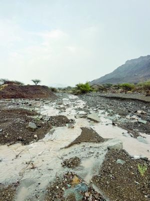

Oman thunderstorms bring heavy rain across northern governorates
Oman thunderstorms moved across several governorates today, producing scattered but locally intense downpours that caused wadi flows and localized damage. The storm activity was centered over the Al Hajar Mountains and extended to coastal districts along the Gulf of Oman, with authorities reporting light to very heavy rain in parts of Muscat, North Al Batinah and South Al Batinah.
Where and when the heaviest rain fell
Weather reports indicated that light rain fell over several wilayats of Muscat as convective clouds expanded eastward from the highlands. Later in the day, intense showers and thunderstorms affected the North Al Batinah towns of Saham and Sohar, producing heavy to very heavy rainfall accompanied by gusty, descending winds and hail in places.
In South Al Batinah, the Rustaq area recorded variable rainfall amounts, with the most persistent cells located over Wadi Bani Ghafir villages. Meanwhile, parts of the Interior governorate experienced thunderous showers concentrated around Samail and Bidbid. Local authorities documented running wadis and some infrastructure impacts in the mountain and agricultural belt.
Meteorological cause and forecast for continued convective activity
Officials and meteorological assessments attributed the outbreak to vigorous convective development over the Al Hajar range, which lifted humid air from the Gulf of Oman and triggered cumulonimbus formation. The national meteorological service issued guidance indicating that local convective activity is likely to continue into the next day, with additional thunderstorms of varying intensity expected across coastal and adjacent mountain areas.
Therefore, heavy rain and localized wadi flooding remain possible as cells regenerate and move inland. Forecasters cautioned that downburst winds and hail can accompany the most intense cores, increasing the risk to exposed infrastructure and agricultural plots.
Local impacts: roads, farms and utilities
Storm-related water flows were reported on several mountain tracks and valley crossings, with the road linking Saham to areas near Wadi Haibi in the Sohar vicinity seeing concentrated runoff. Furthermore, authorities recorded material damage including a number of affected electricity poles and damage to farm properties in low-lying agricultural areas.
Emergency teams and local municipal crews were mobilized to inspect vulnerable roads and clear obstructed drains. Additionally, service providers began assessing power-line restorations where poles or lines were compromised. Residents were advised to avoid driving through flooded stretches and to secure outdoor equipment and livestock where possible.
Preparedness and public safety guidance
Given the potential for wadi floods and sudden runoff, officials recommended maintaining situational awareness during periods of heavy rain. Motorists were urged not to cross flowing water on roads, and residents in mountain-fringe communities were asked to monitor official updates from local authorities and the meteorological service.
Furthermore, farmers and farm managers were advised to check irrigation channels and loose structures after storms, and to report any utility damage to the relevant service provider. Community centers and civil defense units remain the primary points of coordination should localized evacuation or assistance become necessary.
Background: convective storms and Oman’s summer weather patterns
Convective storms are a common summer phenomenon in Oman when moisture from the Gulf of Oman combines with daytime heating and orographic lift along the Al Hajar Mountains. These conditions often produce isolated to widespread thunderstorms that can be highly variable in intensity and distribution across short distances.
Therefore, sudden heavy rain, hail and gusty winds during this period are not unusual, though they can produce significant short-term impacts when cells track over populated or agricultural areas. The current episode aligns with seasonal expectations for intermittent convective activity during the warm months.
Implications for infrastructure and agriculture
Short-duration intense rainfall can strain drainage networks and damage unreinforced agricultural infrastructure. Crop losses and soil erosion are particular concerns in affected farming zones, while damaged power poles can interrupt irrigation and household services.
Consequently, utility operators and municipal planners may need to accelerate inspections and reinforce vulnerable assets ahead of subsequent convective events. Insurance and agricultural extension services are also likely to receive inquiries from farmers about post-storm losses and mitigation measures.
What to watch next
The national meteorological service forecasts continued local convective activity into tomorrow, with additional thunderstorms possible along the coastal and mountain-contact areas. Residents should watch for updated public advisories, road closure notices and utility status reports as conditions evolve.
In the coming 24–48 hours, authorities will monitor precipitation totals and wadi levels to determine if further emergency measures are required. Therefore, staying tuned to official channels and heeding safety instructions will remain important until the convective pattern subsides.