








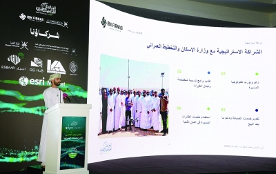

Global Geospatial Information Systems Day Launched in Oman 2026
Today marks the beginning of the Global Geographic Information Systems (GIS) Day 2026, organized by the Ministry of Housing and Urban Planning in Oman. This event showcases the applications of spatial technologies and their role in supporting urban planning, resource management, and sustainable development.
The opening ceremony was officiated by His Excellency Dr. Khalfan bin Said Al Shuaili, Minister of Housing and Urban Planning, in the presence of several esteemed officials from governmental and private sectors in Muscat.
Impact of Geospatial Technologies on Urban Planning
Geospatial applications and technologies play a crucial role in urban planning by integrating land use, population, infrastructure, and environmental data for spatial analysis. This integration aids in identifying optimal locations for projects and services, monitoring urban expansion, and evaluating environmental risks and impacts. Furthermore, it enables planners to compare alternatives and direct investments based on actual needs, enhancing land and resource efficiency.
According to Dr. Mu’men bin Mohammed Al Busaidi, Advisor to the Minister for Smart Cities and Director General of the General Directorate of Geographic Information Systems at the Ministry, this year has seen significant advancements in the use of GIS within the ministry. He notes that these technologies have become a foundational element influencing various aspects of life, necessitating increased public awareness and collaboration between academic institutions and both the public and private sectors.
Innovations in Geospatial Data Collection
In line with its ongoing efforts towards innovation, the ministry announced last year its intention to adopt one of the most transformative technologies—drones. This integration will enhance daily operations by providing high-accuracy spatial and survey data. This year, the ministry successfully trained and qualified 47 licensed drone operators across various governorates in Oman, significantly improving the processing and production levels of maps, which are now fully compatible with artificial intelligence technologies.
Dr. Al Busaidi emphasized that the ministry’s vision extends beyond the confines of its own operations. A virtual center for exchanging geographic data produced by the ministry and other organizations has been established, successfully integrating with key spatial data agencies in Oman, such as Muscat Municipality and Oman Telecommunications Company (Omantel), which operates about 90% of the communication networks.
Advancements in “Geo Oman” Platform
The second iteration of the “Geo Oman” platform has undergone a complete transformation. Initially a data viewing tool, it now relies on spatial intelligence technologies and aerial imagery. The upgraded platform allows for the construction of two- and three-dimensional models and provides a shared workspace for the ministry and relevant agencies to make immediate decisions. Its simplified interface enables users to easily view, analyze, and extract data to support decision-making processes.
Hatem bin Suleiman Al Hatali, Project Manager of the “Geo Oman” platform, presented an overview of its main objectives and functionalities that bolster planning, decision-making, and services related to real estate transactions and integrated residential neighborhoods.
Urban Observatory and Sustainable Development
Zainab bint Abdul Rahim Al Raeesi, Director of the Urban Observatory at the Ministry, highlighted the role and goals of the observatory, detailing its capabilities in spatial analysis, data collection, and plan alignment to support decision-making initiatives.
Today’s activities included signing a collaborative project agreement between the Ministry of Heritage and Tourism, the Ministry of Housing and Urban Planning, and the Academy of Industrial Innovation, focusing on innovative uses of clay brick for contemporary construction and restoration in Oman.
Future Directions in Geospatial Technology
Throughout the event, participants explored various aspects of drone technology’s role in the future of cities, the electronic platform for the Omani urban observatory, and leveraging smart spatial platforms for infrastructure development. A notable presentation highlighted early detection applications for the red palm weevil using multi-sensor imaging from drones and deep learning techniques, with a case study from Northern Oman.
A panel discussion titled “One Technology, Three Perspectives: The Journey of Geographic Information Systems in Oman” projected diverse experiences in utilizing these systems across various fields.
The events will continue tomorrow at the Sultan Haitham City experience center, featuring tours of the main municipal area and activities including the “Geographic Explorer Passport” and practical demonstrations of drone technology. A specialized session on the “Spatial Platform: A New Experience and Advanced Tools” will allow participants to learn about the platform’s tools and applications to enhance skills in utilizing spatial data effectively.
As these initiatives unfold, stakeholders are encouraged to monitor ongoing developments, with an eye toward future innovations that further integrate geospatial technologies into Oman’s urban planning and development strategies.