








3D Marine Survey: New Work Area Announced in Bahrain Territorial Waters
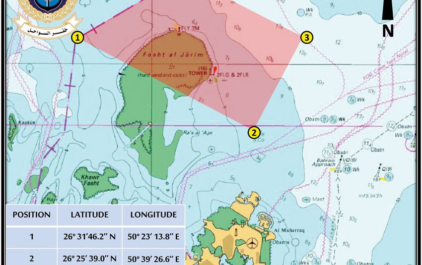
The Ministry of Interior said the Coast Guard has announced a new work area for a 3D marine survey project carried out by Bapco Energies within the territorial waters of the Kingdom of Bahrain. The change takes effect on August 3, 2026, and will remain in place for two months, according to the ministry and the attached operational map provided by officials.
Who Issued the Notice and What It Covers
The Ministry of Interior released the advisory after the Coast Guard formally updated the coordinates and boundaries for the survey operation. Officials said the notice designates an exclusive area for seismic and bathymetric equipment associated with the 3D marine survey, and that the map outlines transit corridors and exclusion zones for other vessels.
According to the statement, the declared area lies inside Bahrain’s territorial waters and will be active during the defined survey period. The change aims to support safe, coordinated operations between the survey vessel, support craft, and other maritime users who frequent nearby routes.
Safety Advisories from the Coast Guard
The Coast Guard urged fishermen, recreational sailors, and all maritime users to exercise caution when navigating near the survey area. Officials advised vessels to maintain a safe speed, avoid approaching or tampering with survey equipment, and follow the marked transit lanes shown on the map. Furthermore, the advisory stressed adherence to any additional instructions issued by Coast Guard units on patrol.
Maritime safety authorities emphasized that interference with instruments could endanger crews and equipment, and that all types of fishing are prohibited within the work area for the duration of the project. The Coast Guard recommended that mariners update voyage plans and remain aware of temporary navigation measures while the operation is under way.
Operational Details and Responsibilities
Bapco Energies is conducting the 3D marine survey as part of its exploration and subsurface mapping program, officials said. While the company is responsible for deploying and monitoring survey arrays and support craft, the Coast Guard retains authority for traffic management and enforcement of maritime safety regulations in the area.
Therefore, coordination meetings between the company, Coast Guard units, and other relevant maritime agencies are likely to precede survey activity. Such coordination is intended to minimize disruption to commercial shipping and local fisheries while ensuring the safety of survey personnel and third parties.
Implications for Fishing and Local Maritime Traffic
The Ministry’s notification expressly forbids all forms of fishing inside the designated work area for the two-month period. Local fishermen were specifically urged to respect the exclusion zones to avoid damage to gear and to prevent hazardous interactions with survey apparatus. Meanwhile, commercial and recreational operators were encouraged to use alternate routes when possible.
For vessels that must transit nearby waters, officials recommended strict compliance with the speed and distance guidelines shown on the map. The restrictions could temporarily alter routine patterns for coastal users, and authorities said they will monitor compliance and issue further advisories as needed to protect both public safety and survey integrity.
Navigation Guidance and Map Access
The ministry indicated that an attached map provides the exact boundaries, waypoints, and safe transit corridors for the operation. Mariners should consult official notices and the Coast Guard for the most current navigation guidance before departure. Additionally, the Interior Ministry suggested that operators file voyage plans and acknowledge instructions from Coast Guard vessels escorting or monitoring the survey.
Those seeking further procedural details or the operational map were directed to contact the Coast Guard or the Ministry of Interior for authoritative information and updates. In practice, timely dissemination of map amendments will be essential if survey lines or schedules change during the two-month window.
Related Considerations for Offshore Operations
Survey projects of this scale typically deploy towed arrays, remotely operated vehicles, and support tenders that extend the operational footprint beyond a single hull. Therefore, maintaining clearances and avoiding acoustic and physical interference are critical. The Coast Guard’s role includes enforcing safety zones to prevent accidental entanglement or collisions that could endanger crews and equipment.
Context and Background on 3D Marine Survey Activities
Three-dimensional marine surveys are standard tools in subsurface exploration and coastal engineering, producing high-resolution maps of seabed topography and sub-bottom geology. According to experts, the data support resource evaluation, environmental assessments, and infrastructure planning. In this case, Bapco Energies’ survey likely aims to refine geological models and inform future activity in the area.
Officials cautioned that while such surveys are routine, they require temporary restrictions to ensure safety and data quality. The Interior Ministry’s public notice reflects a balance between enabling industry operations and protecting public maritime interests and the fishing community.
What to Watch Next: Timeline and Follow-Up Actions
The survey is scheduled to begin on August 3, 2026, and the stated duration is two months, though officials noted that timelines could be adjusted depending on weather and operational factors. Observers should watch for subsequent notices from the Ministry of Interior or the Coast Guard regarding any extensions, modifications to the work area, or additional safety measures.
For the public and maritime stakeholders, the next expected steps include confirmation of daily transit corridors, continued safety briefings, and enforcement of the no-fishing rule within the exclusion zones. Authorities indicated they will issue updates as needed to reflect operational progress and changing conditions.
Conclusion and Forward Look
The Ministry of Interior’s announcement of a revised work area for the 3D marine survey by Bapco Energies formalizes temporary navigation and fishing restrictions inside Bahrain’s territorial waters beginning August 3, 2026. Mariners and local communities should monitor official channels, heed Coast Guard guidance, and plan accordingly for the two-month activity. Looking ahead, stakeholders will be watching for follow-up advisories, any schedule adjustments, and the eventual release of survey findings that may inform future maritime and energy planning.