The Heritage Library at Qatar National Library boasts over 1,200 sheet maps and a variety of atlases, offering a glimpse into cartographic history from the late 15th to the mid-20th century. This collection spans the Arabian Peninsula, the Gulf region, and beyond into Africa, Asia, the Indian subcontinent, and the Ottoman Empire, showcasing a world in transition through maps. One of the highlights of the Library’s collection is the ‘Tabula Asiae VI’ (The Sixth Map of Asia), an early printed map from Claudius Ptolemy’s Geographia. Engraved by Conrad Swenheym and printed in 1478, this map is historically significant as it features the earliest known mention of Qatar, then labeled as ‘Catara,’ on a print map, serving as a bridge between Roman and medieval European cartographic traditions.
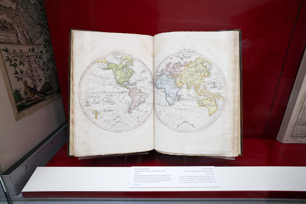
Another notable piece in the Library’s collection is a 4.35-meter-long Ottoman manuscript strip map from the mid-17th century, illustrating the journey of the Tigris and Euphrates rivers from eastern Anatolia to the Arabian Gulf. Attributed to the renowned Ottoman traveler Evliya Celebi, this geographical masterpiece showcases numerous cities and historical routes. The collection also features the exceedingly rare ‘Cedid Atlas Tercümesi’ by Mahmud Raif Efendi, printed in only 50 copies, with nearly half destroyed during a Janissary mutiny, making it one of the world’s rarest atlases. Additionally, the Library holds a unique heart-shaped world map from 1559 by Haji Ahmad, printed in only 24 copies in Venice in 1795, with QNL holding one of the approximately twelve surviving copies.
The influence of the European Age of Discovery is evident in the Library’s collection with the presentation of Joan Blaeu’s 11-volume Latin first edition of Atlas Maior from 1662, one of the best illustrations of Dutch cartography. The collection offers a comprehensive look at the evolution of mapmaking and the exploration of new territories through the centuries. Visitors to the Heritage Library at Qatar National Library can immerse themselves in the rich history of cartography, from ancient Roman traditions to medieval European maps and beyond. The collection showcases Qatar’s early global recognition and highlights its importance in the world of cartography.
Overall, the Heritage Library’s collection of over 1,200 sheet maps and atlases provides a unique and comprehensive view of cartographic history from the late 15th to the mid-20th century. With rare and historically significant pieces such as the ‘Tabula Asiae VI’ and the Ottoman manuscript strip map, the Library offers a valuable resource for researchers, historians, and cartography enthusiasts. The diverse range of maps spanning the Arabian Peninsula, the Gulf region, Africa, Asia, the Indian subcontinent, and the Ottoman Empire reflect a world in transition and provide insight into the evolution of geographical knowledge over the centuries. The collection’s rare and unique pieces, such as the ‘Cedid Atlas Tercümesi’ and the heart-shaped world map by Haji Ahmad, offer a glimpse into the rare and exquisite examples of early mapmaking.
The Heritage Library at Qatar National Library serves as a hub for exploring the rich history of cartography and understanding the significance of maps in shaping our understanding of the world. With its diverse and rare collection of maps and atlases, the Library offers a unique opportunity to delve into the history of exploration, navigation, and geography. From ancient Roman traditions to medieval European cartography and beyond, the collection at QNL showcases the evolution of mapmaking and the exploration of new territories. Whether researching Qatar’s early global recognition or exploring the influence of the European Age of Discovery, the Heritage Library’s collection provides a valuable resource for those interested in the history of maps and the impact of cartography on our understanding of the world.


